
BUNER Flood Crisis: A Community Shattered but Standing Strong
Overview :
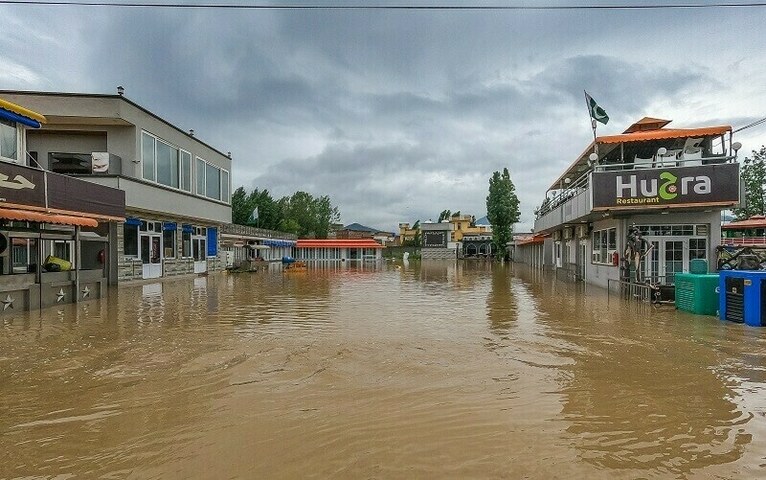
1.In mid-August 2025, KP endured catastrophic flash floods and cloudbursts, particularly in central and northern districts like Buner, Swat, Bajaur, Mansehra, Battagram, Shangla, Lower Dir, and.
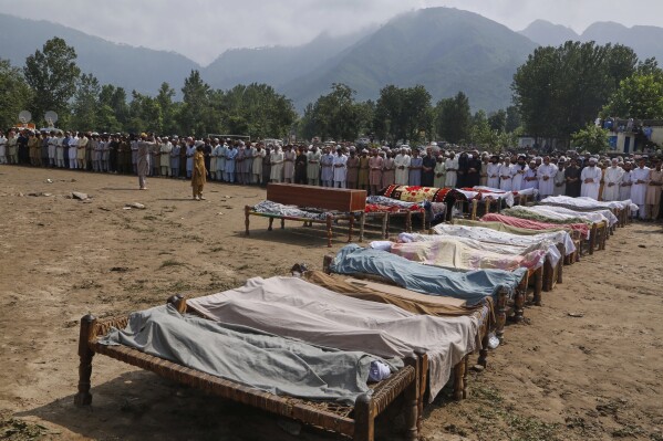
Buner District, especially the Pir Baba area, was the hardest hit, with around 184 deaths.
Other affected districts include Shangla, Mansehra, Swat, Bajaur, Battagram, Lower Dir, and Abbottabad Outlook
2. Fatalities and Damage
The death toll across KP has surpassed 300, with PDMA and NDMA reporting between 307 to 321 confirmed fatalities
A Mi-17 rescue helicopter crashed during operations under adverse weather, claiming the lives of all five crew members Infrastructure across regions was severely impacted—with washed-away roads, bridges, buildings, power lines, and blocked routes due to landslides Reuters
3. Rescue Efforts & Relief Measures
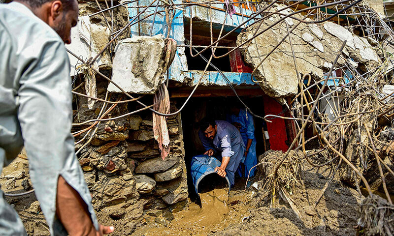
Rescue operations are underway with help from civilian rescue teams (Rescue 1122), military units, and federal agencies (NDMA). Efforts include evacuations via air and ground, setting up medical camps, distributing food and shelter, and repairing infrastructure.
The Pakistan Army has played a pivotal role: dispatching units, contributing rations, executing bridge repairs, donating a day’s salary, and deploying rescue dogs and helicopters
Prime Minister Shehbaz Sharif convened an emergency meeting with NDMA, promising full federal support including dispatching essential supplies, enhancing coordination and evacuation procedures.
Emergency funding has been allocated: ~Rs 500 million in total, with specific disbursements such as Rs 150 million for Buner and Rs 100 million each for Bajaur, Battagram, and Mansehra; Swat receiving Rs 50 million Business Recorder.
4. Ongoing Risks
Authorities continue warning of more heavy rainfall and landslides through August 19–21, heightening the risk of further flooding Residents remain vulnerable as many areas are still inaccessible, and further rescue operations are being impeded by blocked roads and worsening weath
News About flood in Buner District
About Buner District
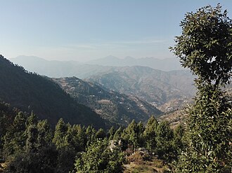
Geography & Environment
- Buner spans from the plains of Totalai in the south (1,200 ft) to the heights of Dosara Peak near Elum Ghar in the north (9,550 ft)
- The landscape is characterized by pine-covered hills and a network of springs and streams, like Barandu, Chamla, and Budal, vital for irrigation and drinking water.
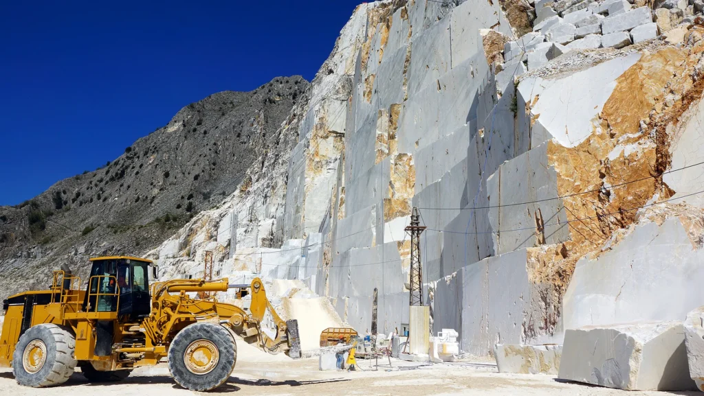
- The region is environmentally significant but faces challenges such as deforestation, pollution from marble factories and tobacco barns, and contaminated water sources
- Buner is a district in Khyber Pakhtunkhwa, Pakistan, characterized by hilly terrain and a rural environment. It lies between 34-9 and 34-43 N latitude and 72-10 and 72-47 E longitude. The district is bordered by Swat, Malakand, Mardan, and the Indus River. The area features a variety of elevations, with the Dosara peak reaching 9,550 ft and the Totalai area in the south at 1200 ft. Three main rivers, Barandu, Chamla, and Budal, flow through the district.
- Hilly Landscape:
- River System:
Economy & Demographics
- Agriculture is the mainstay of livelihoods, with key crops including sugarcane, wheat, maize, and tobacco
- Buner contributes around 68% of Pakistan’s marble reserves. It hosts about 450 marble processing factories and 316 mines, generating significant government revenue
- The population is predominantly rural, and the literacy rate varies by tehsil—from approximately 39% to 48%.
- The largest towns include Torwarsak (~35,165), Totalai (~24,562), Rega (~23,726), and Ellai (~23,678)
Administrative Setup & Education
The district is divided into six tehsils: Daggar, Gadezai, Gagra, Khudu Khel, Chagharzai, and Mandanr
The University of Buner, a public university approved in 2012, offers programs in sciences, arts, and humanities across departments like Computer Science, Economics, English, and more
Cultural & Historical Highlights
Ranigat, an archaeological site dating back to the 2nd century CE, lies within Buner. A remnant of the Gandhara civilization, it’s home to Buddhist-era stupas and ancient ruins atop a hill—a testament to the region’s historical importance
Elum Ghar (Mount Elum), rising to about 2,800 meters, holds religious significance— formerly a Hindu pilgrimage site linked to ancient legends and possibly Buddhist lore
The district also forms part of historical routes, like the paths traversed by Alexander the
Great and later Mughal armies through passes such as Karakar and Ambela
Buner & the 2025 Floods
Buner was the hardest-hit area during the mid-August 2025 flash floods triggered by cloudbursts and heavy monsoon rains.
The district alone reported over 150 to 200+ deaths—some reports state 157, others cite 208 in 48 hours, and general totals of 184 fatalities—highlighting the severity of the disaster
Villages like Pir Baba, Beshonrai, and Malik Pura were especially devastated, with dozens of lives lost and entire homes swept away.
Rescue efforts from Rescue 1122, military, and federal agencies were underway, though hampered by blocked roads, continuing rains, and even a helicopter crash that claimed five crew members.
The monsoon-related flooding continues to raise concerns due to climate change and weak infrastructure planning
Pingback: Flash Floods and Landslides in KP: Climate crisis - Fact Hub